|
|
 |
 |

This is the height of the mountain above sea level. However, on the climb, it is the ascent that matters, i.e. the sum of all the uphill parts of the route.
| Altitude |
|
974 m (3195 ft)
|

This is the standard notation used on Ordnance Survey Landranger maps.
Each reference consists of two letters identifying a 100,000 metre square block then three digits defining the Easting and finally the three digits defining the Northing with reference to the South West corner of the block.
NN166712 is the grid reference for the summit of Ben Nevis. Where you are given the map number ( For Ben Nevis = 41) it is acceptable to omit the two initial letters e.g. 166712. (Instructions on how to read the references are given on the OS maps).
| Grid Ref. |
|
NN36700284
|
|
 |

An indication of this mountains height rank within its class. Where two mountains share the same height they are ordered alphabetically.
| Stature |
|
184 of 282 Munros |

The number of ascent routes currently available on Munromagic.
| Routes |
|
2
|
|
 |

Mountain names are usually in Gaelic, the native language of the Scottish Highlands, or have been derived from the old Scots and Norse languages. We give the most commonly accepted meaning, but accept that some of these are disputed.
| Meaning |
|
Beacon hill |
|
| |

The UK is covered by 204 Ordnance Survey Landranger 1:50,000 scale maps. Maps numbered 1 to 86 cover Scotland but for the highest mountains (Munros) only 23 maps are required. The name given roughly describes the area covered by the map.
|
OS Landranger Maps Required |
|
|
| 56 |
Loch Lomond & Inveraray |
|
|
|
|
|
|
Ben Lomond is a solitary and distinctive peak to the E of Loch Lomond. From the Arrochar Alps, to the NW, Ben Lomond appears to have a conical summit but there is a craggy corrie high on its N slopes. N slopes are steep and craggy but S slopes are easy to moderate. The normal access routes lead from the S and do not encounter the crags until near the summit. Ben Lomond has two parallel SSE ridges, to the W is the Ptarmigan Ridge and to the E the Sron Aonaich ridge. The "tourist" path cuts a broad swathe from Sron Aonaich to the summit. The ascent path by the burn that casacdes between Tom Fitich and Tom Eas at the S end of the Ptarmigan ridge is steeper and much more attractive. Following the Ptarmigan ridge leads to the W face of Ben Lomond from where a minor scramble through rocky outcrops leads to the summit.
|

|
Hazards you may encounter on Ben Lomond include
|
| Steep slopes on or near ascent routes. |
|
| Crags on or near ascent routes. |
|
| Crags near summit. |
|
| Scrambling (minor), easy hand and footholds. |
|
|
| |
|
General Considerations
|
| Temperature decreases by 1degree C for every 100m of ascent. |
|
| Wind usually increases with altitude. |
|
| Visibility can change markedly with cloud level. |
|
| River/Stream levels can increase markedly in one day. |
|
|
|
 |
|
|
|
 |
|
|
 |

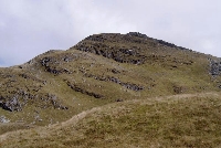
Summit of Ben Lomond looking back from Ptarmigan on the descent, August 2006
© Mark Stevens
|
|
Image by Mark Stevens
|
|

Looking South from Ben Lomond in summer sunset.
© Eric Mc gougan
|
|
Image by Eric Mc gougan
|
|

Ben Lomond from the north: seen across Loch Lomond from the A82 picnic pulloff just north of Inveruglas.
© David S Brown
|
|
Image by David S Brown
|
|

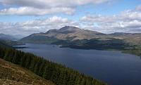
Ben Lomond and Loch Lomond from Beinn Dubh in June 2007.
© Keith Waugh
|
|
Image by Keith Waugh
|
|
 |
|
|
|
 |
|
|
 |
|
|
 |
|
|
 |
|
|
Ascent
|
Distance
|
Time
|
Including...
|
Description
|
Rating
|
|
|
1
|
1006 m
|
11.88 km
|
4.5 hrs
|
Ben Lomond
|
An easy route on a broad eroded path leading all the way to the summit. Can be muddy.
|
  
|
|
|
2
|
996 m
|
11.37 km
|
4 hrs
|
Ben Lomond
|
The "Ptarmigan Ridge Route" is relatively easy but initially on steep slopes, which can be muddy in wet weather. This is a less used path past a beautiful cascading burn with picturesque waterfalls.
|
  
|
|
|
|
|
| |
 |
 |

A great day on Ben Lomond 1/6/16
© Ian Mather
|
|
Image by Ian Mather
|
|

February 2015. A bracing day out on Ben Lomond for Jorja. ;)
© Scott Blair
|
|
Image by Scott Blair
|
|

Top of Ben Lomond, It was busy, Maybe 25 others all drinking their soup :)
© Donald Munro
|
|
Image by Donald Munro
|
|

Gav Man conquers his first ever Munro!
1 down 281 to go.
© Gavin White
|
|
Image by Gavin White
|
|
 |
|
|
|
 |
|
|
 |
|
|
 |
| |
| Showing the most recent 5 of 62 comments. Would you like to view all 62? |
|
|
Alan Melrose
wrote on
May 4, 2014
|
Took the Ptarmigan route up; still snow on the path at the top which made it a little tricky; especially for the young party types who were
coming off the other side in an interesting array of clothing!.. went down the tourist route, hundreds of people on the path including a
group of young guys who had speakers and were playing gangster rap at full blast as they walked down.
Interesting day in the hills; there's only one way to climb this hill if you want peace.
|
|
|
|
John Drummond
wrote on
November 26, 2010
|
Who is it that gives us real hill walkers a bad name???
Well take a trip up Ben Lomond on a mid November typical winter's day, with thick cloud at 2,000ft, constant seasonally cold drizzle, approximately a foot of wet snow and slippery ice from 2,500ft and then marvel at the crazies and dummies out on the tourist path. Turns into somewhat of a fashion parade as we see young girls in long flowing light dresses, athlete types in nothing but tight lycra & trainers, 2 Irishmen in golf shoes and chinos, OAPs setting out on their accent in late afternoon, need I say more?? Idiots!!
|
|
|
|
Jean Moore
wrote on
September 12, 2010
|
Done my first ever Munro today, went up and down the Ptarmigan route, took 6 hrs up & down with a few stops on the way, didn't realise how steep it was in places, my legs were killing me on the way down, good job I had a walking pole with me (nearly never took it) got some good pics on my phone on the way up but the top was too misty for any decent pics, then I dropped my phone (only got it last week) and cracked the screen. Barring the phone incident (still fuming) it was an enjoyable day out, hopefully the first of many more Munros.
|
|
|
|
Kenny Wallace
wrote on
September 7, 2010
|
Went up on the Ptarmigan route and came back down on the Tourist path. Started walking early in the morning so didn't see anyone on the approach to the summit. Visibility was zero on the summit so no good views but must have passed about 70 people walking the tourist route up. Having went both routes was well happy I went up on the Ptarmigan route. Took just about 4 hours.
|
|
|
|
William Mulholland
wrote on
August 15, 2010
|
climbed my first munro today with my son (18) silly name for a boy, started at 7am and made the peak at 8.40, went the easier way anti clockwise from the car park at the pier through the woods, and came down the steep way, glad it did it that way!
great views and a great day for both of us
ill be back one day to do it the other way...
|
|
|
| |
|
|
|
|
 |

|
|
 |
|
|
 |
|
|
